Analysis - Connectivity, Integration & Choice - Overview
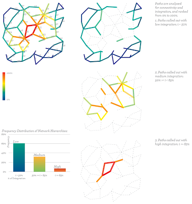
Paths in the generated network are analysed by their connectivity and integration within the tissue. Integration here is taken from the method developed by Bill Hiller / Space Syntax. This measures the accessibility for destination of trips for each space or path. Each path is ranked from the least to the most integrated by a percentage ranging from 0 to 100%.
Path Ratings
Following, the paths are divided in three categories of integration(i). These will be used to apply programmes resulting in different path characteristics throughout the whole tissue:
- - The low integrated paths (i < 50%). These are emerging at the outskirts of the tissue and most likely to change when new paths are added.
- - The medium integrated paths (50% >= i < 85%). These paths are connecting the low with the high paths and connect mostly to the major hubs in the tissue.
- - The high integrated paths (i >= 85%). This category represents the most integrated paths and therefore the most likely paths where activity concentrates. These streets will become the high streets in the tissue with commercial frontages and farmers’ markets located within the urban space.
Sectional Programming - Overview
Path programmes can be divided into linear/routes and points/nodes that serve those routes. A bus route for example requires a bus lane for movement and a shelter, or at minimum standing space, for a stop.
Therefore we will address the paths primarily in section, allocating widths for routes and positions for nodes relative to those routes. These sectional locations we will call programme zones.
Each path will be allocated space for four types of programme zones, these are as follows:
Public/Private Transition
This is the area directly adjacent to the building facade. We will encourage a ‘soft’ transition between public/private by allocating space for and encouraging:
- - Sidewalk retail and seating with transparent/opening facades
- - Front porches and small gardens for residential buildings
Pedestrian Paths
Ample space allocation for pedestrian circulation should make it clear that people will be the priority on our paths. This zone should also be buffered from transit/transport but by soft means, allowing mutability between zones and allowing the whole path to function as an event space at times.
Infrastructure
This zone will accommodate both traditional and 'edible' infrastructures. Included is space for food production, most likely lower maintenance crops, like fruit trees and berry bushes, but will also include space for bus stops, street furniture and lighting.
Transport/Transit
Each path will include space for bicycle traffic and public transit, either bus or tram. Limited space will also be provided for some sort of personal transport vehicle.
The range of widths and relative location of the zones will be determined by the path integration ranking, which we have previously broken into 3 categories - low, medium, and high.
Sectional Programme Components
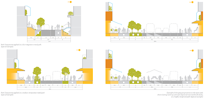
Sectional Components are suggested for the four different zones defined in the previous section. These give actual program and activity to the public space. A library of these components could be implemented and populated over the rated circulatory paths. The examples shown on this page are the first attempt to start building a library and can easily be expanded and change according to, for example, local climatic inputs, technological development or political choices.
Materiality - Overview
The materiality of our public spaces should further our intention of directing flows of energy and resources through the system.
In addition to rainwater runoff and latent heat and solar energy, the urban environment offers opportunities for exchange of information - that is, communication between inhabitants.
We propose that material choices are considered in the interest of harnessing these latent resources.
Example Rules
Path surfaces should be permeable, not paved, and have a dedicated system for the collection of rainwater runoff at street level.
Facade transparency should be relative to path integration. Higher ranked paths should have more transparent facades at street level. Continuity of glazed facades is encouraged, minimising solid opaque facades on highly trafficked streets.
Our intention is to extend the experience of public urban space into the built volumes which line our paths. Glazing will providing exposure for the social/mixing program and encourage communication between public open space and semi-public enclosed programmes.
On the other hand, thick masonry walls with high thermal mass have long been used as heat sinks in traditional greenhouses. We would encourage then, as a material strategy, building envelopes be driven in response to the energetic and information requirements of the programmes.
Sectional Components Applied
In applying the sectional programme components, emphasis should be on walk-able, ‘edible’ streets with a priority given to pedestrian and plantings. Pedestrian paths should be protected from traffic by a permeable boundary of infrastructural components. Street levels should remain continuous to encourage mutability between different uses at different times of day (shown in diagram on right page). The direction of the sun should be considered when placing infrastructure zones, keeping these to the sunny side of the street (where applicable, on primarily East-West streets.)
Path Programmes Applied
When the programmatic zones are assigned to the different categories of circulatory paths, we can see, like the node programmes, a distinct hierarchy of streets results.
The highly integrated paths, near the centre of the tissue, with their wider sectional properties, suggest a high street or retail core. However, our streets will prioritise pedestrians and integrate agricultural production. Lower integrated streets generate less intense and narrower streets, suggesting more residential streets.


